
What risks are incurred by Humans and Climate Change?!
Redlining, the practice of discriminatory lending and insurance practices, has had a significant impact on biodiversity in Roanoke, Virginia. Historically, financial institutions used redlining to restrict access to credit and investment in communities of color, leading to disinvestment, segregation, and economic decline in these neighborhoods. In Roanoke, redlining affected many neighborhoods that were previously home to important natural habitats, such as wetlands, woodlands, and prairies. These habitats supported a wide variety of plant and animal species, but due to redlining and the subsequent neglect of these neighborhoods, these habitats were destroyed or degraded. This has led to the loss of important ecosystems and the displacement of many plant and animal species.
Redlining also contributes to the current problems of pollution and urbanization in Roanoke, as these neighborhoods were often located in areas with heavy industrial or commercial development, leading to increased air and water pollution and further loss of natural habitats. To address the issue of imperiled biodiversity in Roanoke caused by redlining, it is important to invest in communities that were historically affected by redlining, with a focus on creating economic opportunities and improving living conditions. Additionally, the city can work to develop policies that encourage the development of green spaces and natural habitats in these neighborhoods, which will help to improve biodiversity in these areas.

Biodiversity decreases as certain species become extinct or are reduced to low numbers. This is referred to as “endangered biodiversity”. When ecosystems lose their diversity, they become less resilient — meaning environmental changes, such as increased atmospheric carbon dioxide, more easily harm them. Research indicates that ecosystems with high Biodiversity are more productive, less subject to disease, more efficient at cycling nutrients, and better able to adapt to environmental changes. All of this suggests that endangered ecosystems and species are more likely to experience negative consequences of climate change.

Extreme weather events like hurricanes, droughts, and floods are expected to increase in frequency and intensity due to climate change, which means that the habitats of many species in the United States will become less suitable for survival. The effects of climate change are already being seen in Roanoke. A recent study found that the city has seen a 50% decrease in late-spring and early-fall frosts since the 19th century. Other areas of the country have seen frost occur weeks earlier than usual. The loss of frost boosts insect populations, leading to increased pesticide use. It also resulted in early spring and extended growing seasons, negatively impacting certain plant species.
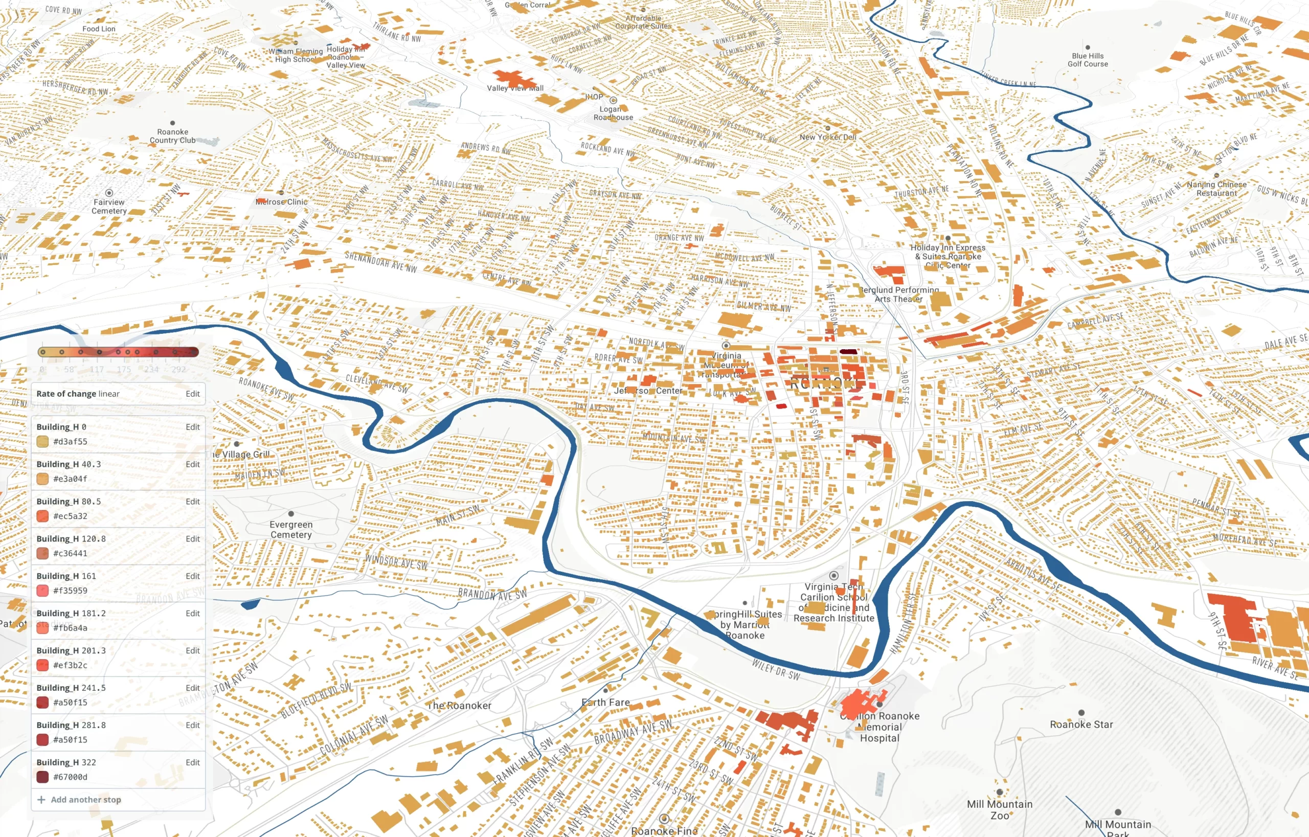
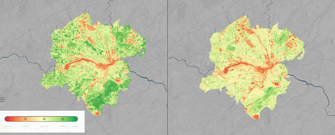
In a heat island, a city’s urban core is noticeably warmer than its surrounding area. These temperature differences result from how humans modify natural landscapes to their needs. Green spaces with fewer built surfaces are cooler than those with more developed areas. Roanoke’s urban core captures most of its heat island effect because it was once the site of heavy redlining by real estate investors who refused to sell land or build homes in certain neighborhoods based on race and class alone. This writing explores some of the histories of redlining in Roanoke, VA, as well as its current consequences. Redlining has lasting effects on urban heat islands and how we approach equity today.
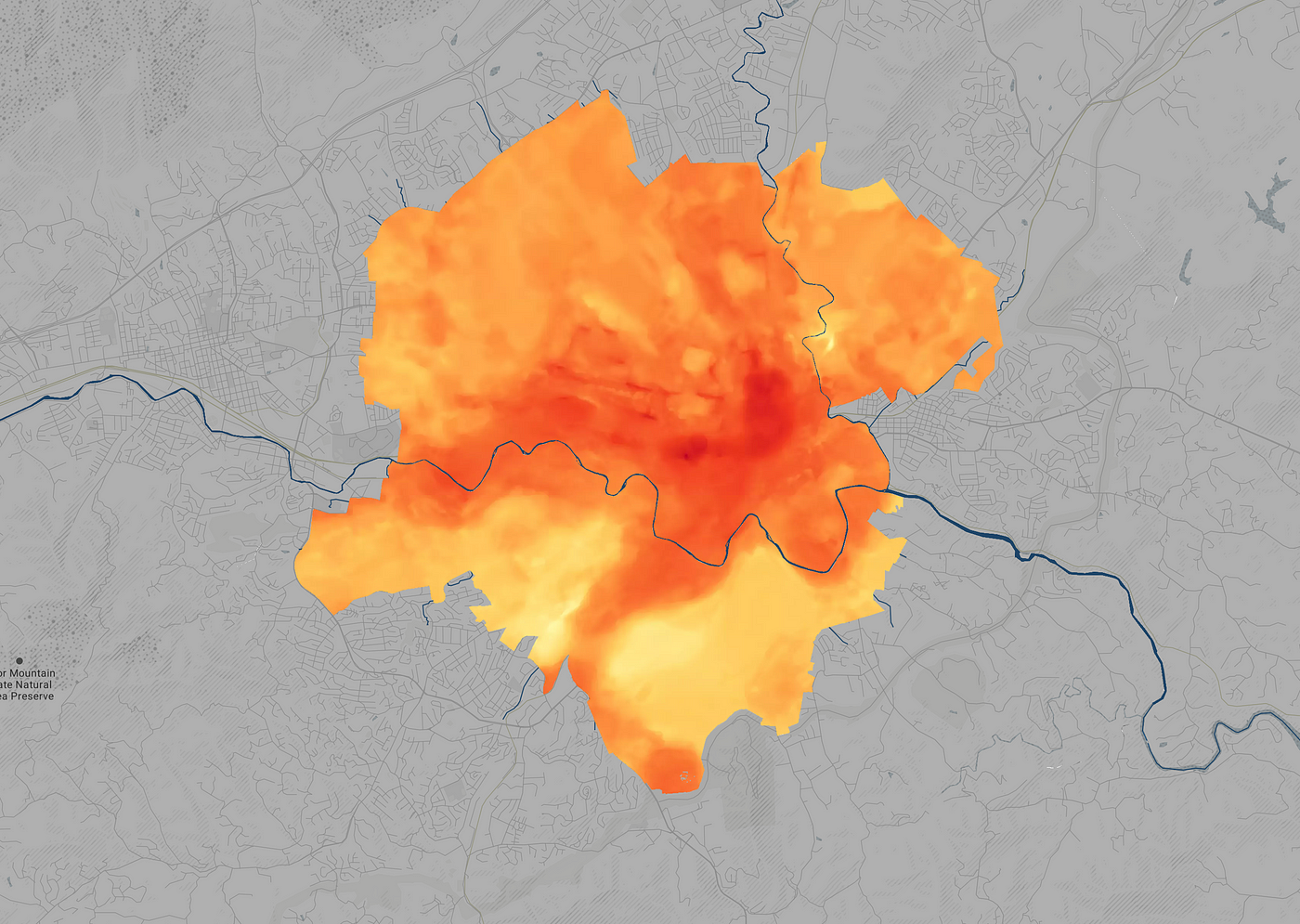
The Roanoke heat island is a more significant problem today because many of the factors that created the heat island in the first place are still present. The urban core continues to be the least desirable place to live in the city. The redlined neighborhoods continue to be underserved, with less access to economic opportunity and lower-quality infrastructure. This makes it difficult for residents in these areas to reduce the heat island effect in their neighborhoods. The lack of city services, like tree planting and removal, in the urban core makes it more difficult for residents to manage stormwater and reduce the heat island effect in their communities. City services are often delayed or completely unavailable in the urban core. This can be attributed to various factors including fewer tax revenues from low-income neighborhoods, access to the areas due to challenging topography, and the prioritization of service for other areas in the city.

Roanoke is prone to flooding because of its location near the James River, and the heat island effect multiplies it. Flooding can be caused by many factors, like heavy rainfall, runoff, or melting snow. In 2014, there were six floods in Roanoke City; Three of the floods were caused by heavy rainfall, and three were caused by runoff. In addition, the city has an urban heat island effect, which makes it warmer than other areas of the same size. The heat island effect is when the city is built up, and there is no vegetation, the city gets hotter. This makes it harder for water to evaporate or soak into the ground because the ground is too hard, and floods are more common in Roanoke.

Extreme weather events like hurricanes, droughts, and floods are expected to increase in frequency and intensity due to climate change, which means that the habitats of many species in the United States will become less suitable for survival. The effects of climate change are already being seen in Roanoke. A recent study found that the city has seen a 50% decrease in late-spring and early-fall frosts since the 19th century. Other areas of the country have seen frost occur weeks earlier than usual. The loss of frost boosts insect populations, leading to increased pesticide use. It also resulted in early spring and extended growing seasons, negatively impacting certain plant species.

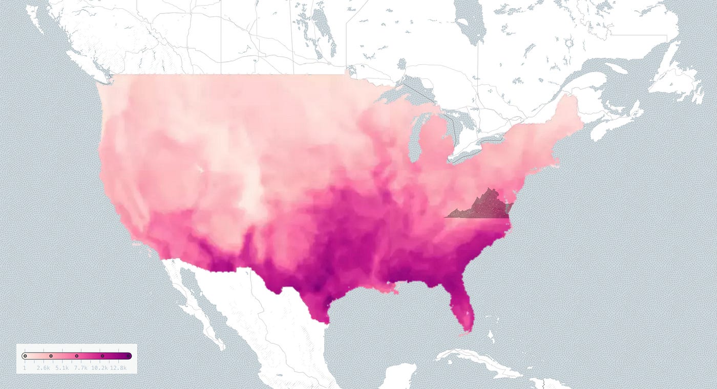
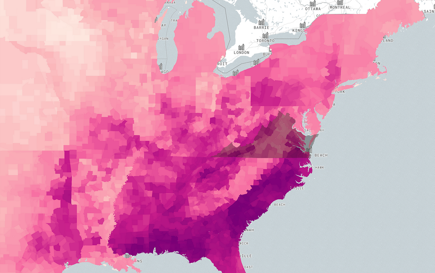
Roanoke has a moderate risk of flooding over the next 30 years due to a changing environment. Deeper floods from major events, like hurricanes, are less likely to occur but affect more properties than more shallow flood events, like heavy rains. A changing environment means higher seas, new weather patterns, and stronger storms. This can increase flooding from hurricanes and offshore storms. Floods cause erosion, which hurts ecosystems and living species. Floods can also kill wildlife, including one- horned rhinos. Unpredictable floods can harm aquatic life and alter the landscape by eroding riverbanks and causing them to collapse. Sedimentation can clog riverbeds and streams, smother aquatic organisms, and destroy habitats. Floodwater can contain harmful substances like agricultural pesticides, industrial chemicals, debris, and sewage. This can affect delicate ecosystems, such as coral reefs.

Another threat to Roanoke’s Biodiversity is the decrease in soil pH. The pH scale ranges from 0 to 14, with 7 being neutral. Numbers below 7 indicate acidity, while numbers above 7 indicate alkalinity. The most common measure of soil pH is the number of hydrogen ions (H+) in a given amount of soil. The higher the H+ concentration, the more acidic the soil. Unusually high or low soil pH can have a negative effect on plant growth. Most crops prefer a slightly alkaline pH of around 6.5 to 7.5. Soil pH levels below 5.5 may be unsuitable for most crops, while above 8.5 may become less nutritious. The main cause of decreased soil pH in Roanoke is the acid rain phenomenon associated with industrial emissions from the power plants in Virginia and other states.

Soil is the loose top layer of the earth’s surface where plant life can grow. It also determines how quickly rainfall runs over and through it to the nearest stream and how much soil the rainwater takes with it. The Soil of Roanoke is primarily Type B and Type D, with high runoff potential and a very low infiltration rate even when thoroughly wet. Runoff is a significant contributor to water pollution as it carries with it various pollutants such as litter, oil, chemicals, fertilizers, and other harmful substances. This can affect soil moisture and soil temperature, ultimately affecting the amount of carbon “locked” into plants. Another threat to Biodiversity in Roanoke is the decrease in soil pH. This is caused by the acid rain phenomenon associated with industrial emissions from the power plants in Virginia and other states. Roanoke has major risks from the Heat because 95% of homes have a Major Heat Factor and the area compares to the rest of the country. Heat waves are becoming more likely as temperatures rise. 30 years ago, the likelihood of a 3-day heat wave in Roanoke was 18%. Heat island effects can significantly impact Biodiversity and ecosystems, including increased pest populations, shifts in species ranges, and decreased water quality and availability for wildlife and plants. Building height can accelerate the heat island effect and create hotspots of higher temperatures in urban areas, increasing the risk of flooding, air pollution, and other health issues.
Biodiversity is important for many reasons — not only for aesthetic reasons but also because it is the foundation for a healthy environment. Unfortunately, Biodiversity is in decline in many parts of the world, including Roanoke. If we want to protect it, we must take action. It is Important to remember that Biodiversity is not only about plants and animals. It is also about the essential microbes and fungi that exist in every ecosystem. We must protect and nurture all forms of Biodiversity if we want our environment to be healthy and resilient. Roanoke has a high degree of Biodiversity, with more than 300 species of birds recorded in Roanoke alone. Researchers estimate that 1,000 species have become extinct in the U.S. since 1600 and believe the world is in the midst of its sixth major extinction event. Fish play an important role in aquatic ecosystems and provide protein for a billion people. Many species face various threats, including the destruction and degradation of freshwater habitats, invasive alien species, and climate change.

Although warm-water fishes are not expected to face the nearly-universal declines predicted for cold-water fishes, they are still impacted by warming waters. Many animals living in warm water habitats, including fishes and invertebrates, are ectothermic, relying on external conditions to regulate body temperature. Environmental temperature strongly influences metabolic rates, the timing of key behaviors, growth, recruitment, bioaccumulation rates, and a suite of physiological processes in ectotherms. Some ectotherms are adapted to a narrow range of temperatures, whereas others are generalists, setting up the potential for winners and losers as temperatures increase; however, all species have upper thermal limits beyond which physiological processes break down. Many native warm-water fishes in the southwestern and central U.S. already live near their maximum thermal limits, so predicted temperature increases would likely cause extirpations and extinctions.
Reptiles and amphibians are cold-blooded species that rely on environmental Heat to regulate their body temperature. They are susceptible to the altered temperatures that may result from climate change. It is believed that lizards living in temperate regions are particularly susceptible to the effects of climate change, which can cause death due to increased temperatures during winter, changes in plant life, changes in wildfire patterns, the introduction of non-native species, and the possibility of disease. Turtles and alligators are sensitive to changes in water availability and thermal properties and have temperature-sensitive sex determination. Storm surges can harm animals by moving them from their homes or submerging them in water, and they can also cause dehydration by introducing saltwater into their freshwater habitats. About 1/3 of amphibian species are already at risk of extinction. Leading threat factors include habitat loss, disease, invasive species, overexploitation, and chemical pollution.
Next, consider their basic biology. Amphibians have been heralded as the Canaries in the Coal Mine, being sentinels of a host of environmental changes due to their biphasic lifestyle with life stages relying on both aquatic and terrestrial systems, their moist permeable skin, which is a sensitive respiratory organ, and their central position in food webs. The scenario becomes even more complex when multiple threats affect single populations, and the synergistic effects of threats together may become more potent than the simple sum of those parts. Now, adding the impact of climate change to this cocktail of multiple threats and climate-sensitive life history modes is worrisome indeed.
Loss of natural habitats poses the most severe danger to the diversity of living organisms, and the fragmentation of the landscape takes an immeasurable toll on Virginia’s Biodiversity.
Roanoke is rich in Biodiversity because of its climate and topography. The loss of a single species can reverberate throughout an ecosystem, and individuals may not try to traverse the matrix to reach other patches. Loss of connectivity is another factor affecting species in fragmented landscapes. Individuals may not try to traverse the matrix to reach other patches if the matrix is harsh. Thus, populations in isolated patches may experience decreased genetic exchange with populations in other fragments. A network of natural lands is the best way to conserve Biodiversity. Large patches contain larger population sizes that make species less susceptible to stochastic variation.
Landscape corridors are important for conserving metapopulations because they facilitate the movement of animals among patches and the dispersal of pollens and seeds. Corridors should also make use of nodes, which are small pieces of habitat that act as stepping stones.
Vegetation in Roanoke has been declining significantly, which has led to a loss of connectivity and climate change. The changing climate increases stressors that weaken plant resilience, disrupting forest structure and ecosystem services. It accelerates the speed of the cycle of vegetation deduction. Rising temperatures cause more frequent droughts, wildfires, and invasive pest outbreaks, leading to plant species losing and intensifying heat islands.
References:
Map Sources: vgin, Esri, USGS, EPA, NPS, OSF, FEMA, iucnredlist, Roanokecountyva, biodiversitymapping
[1] Olson, D.H.; Saenz, D. 2013. Climate Change and Reptiles. (March, 2013). U.S. Department of Agriculture, Forest Service, Climate Change Resource Center. https://www.fs.usda.gov/ccrc/topics/reptiles-and-climate-change
[2] Roghair, C.; Adams, S. B. 2019. Warmwater Aquatic Fauna and Climate Change. (April 2019). U.S. Department of Agriculture, Forest Service, Climate Change Resource Center. https://www.fs.usda.gov/ccrc/index.php/topics/warmwater-aquatic-fauna-andclimate-change
[3] Olson, D.H.; Saenz, D. 2013. Climate Change and Amphibians. (March, 2013). U.S. Department of Agriculture, Forest Service, Climate Change Resource Center. https://www.fs.usda.gov/ccrc/topics/amphibians-and-climate-change
[4] Emmet Duffy, J., Lefcheck, J. S., stuart-Smith, R. D., & Edgar, G. J. (2016). Biodiversity enhances reef fish biomass and resistance to climate change. PNAS. https://doi.org/10.1073/pnas.1524465113
[5] (n.d.). Virginia ConservationVision Natural Landscape Needs Assessment. Department of Conservation and Recreation. https://www.dcr.virginia.gov/natural-heritage/vaconvisvnla
[6] (n.d.). Soil. N.C. Environmental Education. https://www.eenorthcarolina.org/resources/your-ecological-address/soil
[8] (n.d.). Digital Distribution of Native U.S. Fishes by Watershed. NatureServe. https://www.natureserve.org/products/digital-distribution-native-us-fishes-watershed
[9] (n.d.). Reptiles & Amphibians. National Park Service. https://www.nps.gov/rich/learn/nature/herps.htm
[10] (n.d.). Natural Resources Canada. Land Cover & Land Use. https://www.nrcan.gc.ca/maps-tools-and-publications/satellite-imagery-and-airphotos/tutorial-fundamentals-remote-sensing/educational-resources-applications/landcover-biomass-mapping/land-cover-land-use/9373
[11](n.d.). The Many Effects of Flooding. National Geographic Society. https://education.nationalgeographic.org/resource/many-effects-flooding
[12] (n.d.). Runoff. National Geographic Society. https://education.nationalgeographic.org/resource/runoff
[13] (n.d.). pH and Water. USGS. https://www.usgs.gov/special-topics/water-scienceschool/science/ph-and-water
[14](n.d.). Soak Up the Rain: Whats the Problem? US EPA. https://www.epa.gov/soakuptherain/soak-rain-whats-problem
[15] McCarthy, Alex. “As Roanoke Grows Hotter, Poor and Black Neighborhoods Face the Most Danger, Study Shows.” The Roanoke Rambler, The Roanoke Rambler, 1 Sept. 2021. https://www.roanokerambler.com/as-roanoke-grows-hotter-poor-and-black-neighborhoods-face-the-most-danger-study-shows/.